Issued at: 5:00AM today, 25 November 2016
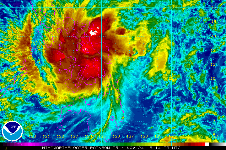
SYNOPSIS: At 4:00 am today, the center of Tropical Depression "MARCE" was estimated based on all available data including Mactan Doppler Radar at 60 km west of Baybay, Leyte (10.8°N, 124.7°E) with maximum winds of 55 kph near the center and gustiness of up to 95 kph. It is forecast to move west northwest at 19 kph.
PAGTAYA: Mga pag-ulan na may pagbugso ng hangin ang iiral sa Kabisayaan, mga lalawigan ng Mindoro, Romblon, Hilagang Palawan, Masbate at mga isla ng Cuyo, Calamian at Lubang. Maulap na kalangitan na may katamtaman hanggang sa kung minsan ay malakas na mga pag-ulan at pagkidlat-pagkulog na maaaring magdulot ng mga pagbaha at pagguho ng lupa ang mararanasan sa nalalabing bahagi ng Kabikulan at mga lalawigan ng Marinduque at Quezon. Maulap na kalangitan na may mahina hanggang sa katamtamang mga pag-ulan at pagkidlat-pagkulog ang inaasahan sa Kamaynilaan at sa nalalabing ng bansa.Katamtaman hanggang sa malakas na hangin mula sa hilagang-silangan ang iiral sa nalalabing bahagi ng Luzon at mula naman sa hilagang-silangan hanggang sa hilagang-kanluran sa nalalabing bahagi ng Mindanao na may katamtaman hanggang sa maalong karagatan.
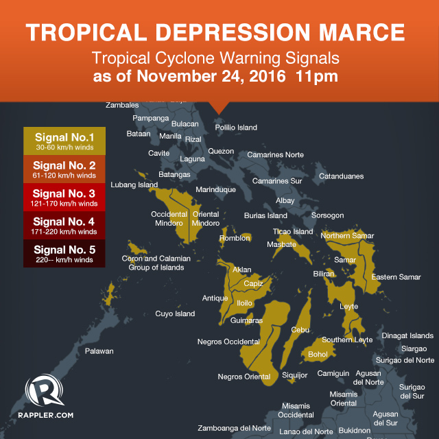
Signal number 1 is raised in the following areas:
Romblon
northern Palawan including Cuyo Island and Calamian Group of Islands
Oriental Mindoro
Occidental Mindoro including Lubang Island
Masbate
Biliran
Samar
Eastern Samar
Northern Samar
Leyte
Southern Leyte
Bohol
Cebu including Bantayan and Camotes Islands
Siquijor
Negros Oriental
Negros Occidental
Iloilo
Capiz
Aklan
Antique
Guimaras
sources: http://pagasa.dost.gov.ph/ & http://www.rappler.com/
SYNOPSIS: At 4:00 am today, the center of Tropical Depression "MARCE" was estimated based on all available data including Mactan Doppler Radar at 60 km west of Baybay, Leyte (10.8°N, 124.7°E) with maximum winds of 55 kph near the center and gustiness of up to 95 kph. It is forecast to move west northwest at 19 kph.
PAGTAYA: Mga pag-ulan na may pagbugso ng hangin ang iiral sa Kabisayaan, mga lalawigan ng Mindoro, Romblon, Hilagang Palawan, Masbate at mga isla ng Cuyo, Calamian at Lubang. Maulap na kalangitan na may katamtaman hanggang sa kung minsan ay malakas na mga pag-ulan at pagkidlat-pagkulog na maaaring magdulot ng mga pagbaha at pagguho ng lupa ang mararanasan sa nalalabing bahagi ng Kabikulan at mga lalawigan ng Marinduque at Quezon. Maulap na kalangitan na may mahina hanggang sa katamtamang mga pag-ulan at pagkidlat-pagkulog ang inaasahan sa Kamaynilaan at sa nalalabing ng bansa.Katamtaman hanggang sa malakas na hangin mula sa hilagang-silangan ang iiral sa nalalabing bahagi ng Luzon at mula naman sa hilagang-silangan hanggang sa hilagang-kanluran sa nalalabing bahagi ng Mindanao na may katamtaman hanggang sa maalong karagatan.
Signal number 1 is raised in the following areas:
Romblon
northern Palawan including Cuyo Island and Calamian Group of Islands
Oriental Mindoro
Occidental Mindoro including Lubang Island
Masbate
Biliran
Samar
Eastern Samar
Northern Samar
Leyte
Southern Leyte
Bohol
Cebu including Bantayan and Camotes Islands
Siquijor
Negros Oriental
Negros Occidental
Iloilo
Capiz
Aklan
Antique
Guimaras
sources: http://pagasa.dost.gov.ph/ & http://www.rappler.com/
Last edited by a moderator: