- Joined
- Jun 12, 2014
- Messages
- 2,415
- Reaction score
- 31
- Points
- 381
MANILA, Philippines – Typhoon Lawin (Haima) again intensified before dawn on Wednesday, October 19, as it continued to threaten Northern Luzon.
In its bulletin issued 5 am on Wednesday, state weather bureau PAGASA said Lawin now has maximum winds of up to 205 kilometers per hour (km/h) and gustiness of up to 255 km/h.
The typhoon is already 535 kilometers east of Casiguran, Aurora, moving west northwest at a slightly faster 26 km/h from the previous 25 km/h.
Moderate to intense rain is expected within Lawin's 700-km diameter.
Signal number 2 is raised in the following areas:
Cagayan including Calayan Group of Islands
Isabela
northern Aurora
Ilocos Norte
Ilocos Sur
Apayao
Abra
Kalinga
Mt Province
Ifugao
Benguet
Nueva Vizcaya
Quirino
Signal number 1, meanwhile, is up in these areas:
Batanes
La Union
Tarlac
Pangasinan
Nueva Ecija
rest of Aurora
Zambales
Pampanga
Bulacan
northern Quezon including Polillo Island
Bataan
Rizal
Laguna
Camarines Norte
Camarines Sur
Catanduanes
Metro Manila
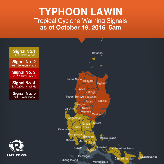
PAGASA earlier warned that Lawin could become a super typhoon. In the state weather bureau's classification, a super typhoon has maximum winds of at least 240 km/h.
Signal number 4 or 5 might be raised in Cagayan (including the Calayan Group of Islands), Apayao, Ilocos Norte, and northern Isabela on Wednesday night.
If indeed these areas are placed under signal number 4 or 5, there would be very strong winds 220 km/h or more and gustiness of up to 365 km/h or more.
Such winds "can destroy high- to low-risk structures" as well as topple trees and transmission towers, according to the state weather bureau.
Storm surges up to 5 meters high are also possible in Cagayan (including the Calayan Group of Islands), Isabela, and Ilocos Norte.
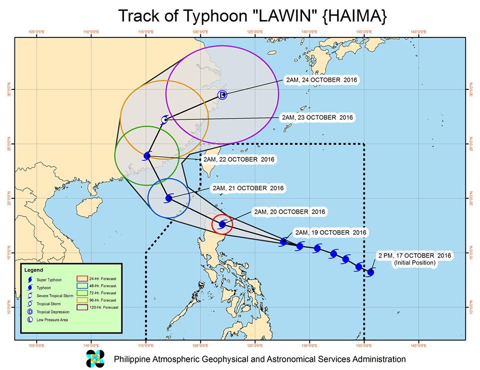
Lawin is expected to make landfall in the Cagayan area early Thursday morning, October 20. The Cayagan provincial government has said that it is preparing for a "worst-case scenario."
After making landfall, the typhoon will cross Ilocos Norte and Apayao.
PAGASA also said sea travel is risky in the eastern seaboard of Southern Luzon and the northern and eastern seaboards of Samar.
Lawin is expected to leave the Philippine Area of Responsibility (PAR) either on Thursday night or early Friday, October 21.
source: RAPPLER.COM
maghanda at mag-ingat po tayo
br,
bojs
In its bulletin issued 5 am on Wednesday, state weather bureau PAGASA said Lawin now has maximum winds of up to 205 kilometers per hour (km/h) and gustiness of up to 255 km/h.
The typhoon is already 535 kilometers east of Casiguran, Aurora, moving west northwest at a slightly faster 26 km/h from the previous 25 km/h.
Moderate to intense rain is expected within Lawin's 700-km diameter.
Signal number 2 is raised in the following areas:
Cagayan including Calayan Group of Islands
Isabela
northern Aurora
Ilocos Norte
Ilocos Sur
Apayao
Abra
Kalinga
Mt Province
Ifugao
Benguet
Nueva Vizcaya
Quirino
Signal number 1, meanwhile, is up in these areas:
Batanes
La Union
Tarlac
Pangasinan
Nueva Ecija
rest of Aurora
Zambales
Pampanga
Bulacan
northern Quezon including Polillo Island
Bataan
Rizal
Laguna
Camarines Norte
Camarines Sur
Catanduanes
Metro Manila
PAGASA earlier warned that Lawin could become a super typhoon. In the state weather bureau's classification, a super typhoon has maximum winds of at least 240 km/h.
Signal number 4 or 5 might be raised in Cagayan (including the Calayan Group of Islands), Apayao, Ilocos Norte, and northern Isabela on Wednesday night.
If indeed these areas are placed under signal number 4 or 5, there would be very strong winds 220 km/h or more and gustiness of up to 365 km/h or more.
Such winds "can destroy high- to low-risk structures" as well as topple trees and transmission towers, according to the state weather bureau.
Storm surges up to 5 meters high are also possible in Cagayan (including the Calayan Group of Islands), Isabela, and Ilocos Norte.
Lawin is expected to make landfall in the Cagayan area early Thursday morning, October 20. The Cayagan provincial government has said that it is preparing for a "worst-case scenario."
After making landfall, the typhoon will cross Ilocos Norte and Apayao.
PAGASA also said sea travel is risky in the eastern seaboard of Southern Luzon and the northern and eastern seaboards of Samar.
Lawin is expected to leave the Philippine Area of Responsibility (PAR) either on Thursday night or early Friday, October 21.
source: RAPPLER.COM
maghanda at mag-ingat po tayo
br,
bojs